Thursday, January 1, 2015

Eastern Lower Galilee שביל עמק המעיינות יבנאל - נחל תבור - בית שאן


The bus door was just barely wider than the green backpack, but I squeezed out of it and into the town anyway. Low basalt houses lay against hazy green hills. After a few hundred meters the houses became orange trees with shadowy dark leaves. I followed the dirt road without shade which should have had red blazes, until a shortcut led uphill past an orange grove.

Well, as long as it was going past the orange grove it led uphill. After that it was vertical. After an hour or so of climbing I could see from Mt. Tabor to the Kinneret. As for mileage, I had one kilometer down and an indeterminate but unreasonably long distance to go, but you have to keep things in perspective.
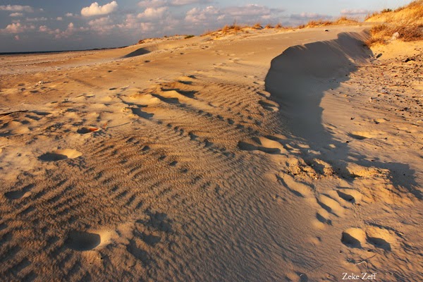
View of the Kinneret and Jordan valley

The trail - with blazes - was a farm road going south. That is, because nothing in life is simple, it was a network of farm roads and mostly went south but sometimes decided that west or east would be much more fun. Tire tracks in the mud had baked very dry and very hard.

The trail-insofar-as-it-was-a-unitary-object went down into and came up from a wadi, which was very green and had a puddle in the channel (This is called winter). Further on, I saw a car, a few people, and a large black puppy. Feel free to guess which one of these wagged its tail and ran towards me.
Mt Tabor from the trail

"It's OK, he's a nice dog," one of the picnickers assured me.
I petted the puppy.
"You're alone? You need a ride?" Hitchhiking is much more accepted in Israel than in the US. My theory is that there's a sense of community and kinship leading to a sense that a stranger isn't a risk. That, or people think I'm lost.
"I'm all right."
He picked up the puppy and carried it back to the car.
"Where are you going to end up today?"
"Today I'm not ending up anywhere. Tomorrow - Beit She'an."
"You've got water?"
The water bottles were on the outside of my pack, but it's another thing people say to hikers.
"Yes, yes, thanks."

The area between the Kinneret and the West Bank is mostly rolling hills above deep wadis. The hills are farmland, and in early winter the wheat was just sprouting. The path kept turning. Mt. Tavor and Nazareth got further away, very slowly. Late in the day I climbed out of one last wadi up to an onion field on the hilltop. A man was lying in an impossibly relaxed way on the hard black earth next to it. He said something to me. After asking him twice what it was, I walked over to him.
The path

"You don't get tired walking around with a heavy pack all day?"
Well... 
"I enjoy it. I like hiking," was the best I could come up with.

The sunset lit the fields very softly. The path still crossed rolling hills, but the hills were very wide and round at the top instead of peaked or flat - like a pillow. I stopped at sunset just outside the next wadi, though it was a full moon night. I did some homework by the light of the full moon but couldn't actually tell whether it was legible or not.

I woke up at moonset. The moon faded, turned yellow and red just like the sun had, and sank slowly behind Nazareth. Stars appeared and brightened. A shooting star scampered across the sky, and the call to the morning prayer echoed quietly from the mosques across the Jordan valley. I lay in the dark for a few minutes, saw the first gray light in the clouds over Jordan, then got up, shivered, packed very quickly, shivered, and started walking. Stopping at sunset and starting at first light seems smart, but it was much darker now than in the moonlit night. I should have hiked at midnight - the full moon shone for miles.
Folded hills of Nahal Tavor

I made it down to the bottom of the wadi somehow without tripping over a wild boar, but nobody gave me a prize. It was light enough to see color, and the hills were greener than anything I'd seen in months. Winter means regeneration here. 
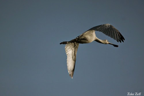
Gazelles leaped
Gazelle
uphill. I tried to imitate them; there were still a few dozen kilometers to go.


The terrain stayed the same, rolling hills with no shade until the wadi, full of dusty date palms and dusty motorcycles racing through. I climbed out of the wadi at high noon and looked down towards the Jordan valley and Beit She'an. A long way down. I wasn't high up, but most of that area is below sea level and hot. Even in the winter. 

I stumbled into Beit She'an in the late afternoon, late enough to be told that I didn't have much time before Shabbat. A sign warned that roads would be closed for a half-marathon, but for some reason I decided not to run it. I found the hotel after some confused wandering and texting.

"Who are you?" This was at the door.
"Are you asking what my name is, or what I'm doing here?"
I don't remember what the reply was, but they let me in. I was too exhausted to come up with the Hebrew words for Conservative Rabbis' Gathering.

I wonder how often people show up to it like that.

Tuesday, November 25, 2014

Upper Hula Valley and Golan

In about three days I walked all the way from the Nashot junction down to the Pkak bridge up to Nahal Sa'ar down to Qiryat Shmona. If you happen to be inspecting a topographic map of the Golan Heights right now, you may still have no clue what I'm talking about. 

Tuesday, October 28, 2014

Northern coastline - fishponds, sand dunes, unexplained explosions, etc.

"...then you should go to Ma'agan Michael. They have fishponds, and the migrating birds stop there," someone said.
All right.
The fishponds aren't just at Ma'agan Michael, which is a kibbutz on the coast midway between Netanya and Haifa; they stretch north for kilometers. On maps the coast looks like a net, full of blue holes.
On the ground at Ma'agan Michael it looked a bit more solid. It supported plenty of tour buses, anyway. The area is not a tourist destination and I saw no groups walking around. I weaved around the buses towards the gray herons. A car stopped.
"Do you know how you can drive onto the beach?" 
I had seen a bike pass on dirt roads beyond the fishpond, but didn't know how to get down to the shoreline. "I'm sorry, I don't know."
"You speak English?" the driver asked in English.
"I speak Hebrew, but I don't know how to get to the beach", I said quickly in Hebrew.
"It would be better if you knew how to get to the beach and didn't speak Hebrew," he said in English.
After he drove on, I turned back to a heron below the banks of a pond, which had speared a fish and was holding it proudly.
Gray heron
I walked around the fishponds and the beach (which wasn't drivable). Ibises, egrets, and others flew about by the dozens, but the place didn't seem crowded. By late afternoon I was hemmed in by No Entry signs and walked out past the kingfishers. I checked a map, found a campground a few km up the coast, and headed north on a path through the fishponds until the gunshots started. Distant ones, but I would have preferred them to be more distant. Walking further north, I heard them much closer, so much closer that I cut across to the road while humming loudly and trying to be very visible. I walked the next kilometer or so by the side of the coast road and walked back toward the fishponds once I was past the shots. A turnoff from the highway led to a dirt road, which led to...
"What's at the end?" A father and son, in dati clothing, were walking in the same direction as I was.
"I'm sorry, I don't know. I have no idea." But I kept walking. In the end, the path followed a stream down to a beach with a conspicuous lack of No Camping signs.
It was late in the day. The dunes and wildflowers already glowed orange. I found a pass between dunes as the sun set through the beachgrass and slept in the sand. I tried literally sleeping in the sand, which was a good insulator, but a cold wind blew over the beach and you can't really burrow into the sand. 
Dawn glowed orange over Zikhron Ya'aqov and Fureidis. It was light enough that I had no trouble seeing the sand dunes, soft and brown in the early morning. A few birds called, but otherwise the beach was peaceful and BAM.
What could possibly improve the morning more than random explosions to the northeast?
I walked in the other direction, back towards the stream, which rippled over the sand where it met the sea. Farther upstream, kingfishers staked out a shady pool. Even farther, egrets stalked the stream and ibises flapped around the fishponds. I walked around the dunes before heading out past the fishponds, long lens ready for birds. A family on bikes stopped by me. Actually, they stopped around me. I wasn't really surrounded but I couldn't see all of them at once. 
"What kinds of birds are around here?"
(שלדג (יש אחד שם! עכשיו אף...לא, הינה הוא
I had some idea of what they were in English, but in Hebrew?...
לבנית
אנפה
ועוד שאני לא יודע את שמם
I mentioned a few birds whose names I knew in Hebrew (some from signs in other parks; one from a random stranger who had helped me identify a kingfisher earlier in the morning) before heading north through the fishponds towards a bus stop- at least until I got boxed in by No Entry signs and headed for the road, at least until I found that the coast road has pedestrian bridges some of the time...
It was a long walk to the bus stop.


Friday, October 17, 2014

Around the Kinneret (also, secrets of not staying dry in a thunderstorm)

Egret across from the mountains and wadis of the northwestern shoreline of the Kinneret
Well, about two-thirds of the way. There is a sixty-kilometer trail all the way around, but I didn't have time. It's a very nice trail, put up "to promote the public right to walk freely on the Kinneret's shores". Several areas on the shore, notably the northern end, are military firing zones (mapped but completely unmarked), in which "the public right to walk freely" is subject to the army's approval, but the trail goes right through. I took the road; firing zones aren't used often, but I didn't have the army's approval, and I don't find unpredictable shooting fun when I'm on the wrong end.


Marshes on the southeast shore
I started at the southern tip of the Kinneret and got off the roads (but into a banana plantation) as soon as I could. Soon the trail dived into the marshes which fringe the Kinneret's eastern coast. I walked through dark tunnels carved out of the heavy-hanging reed-stalks, through fig and blackberry thickets, through bushes and reeds. The lake itself was rarely visible. Every kilometer or so the marsh gave way to rocky beaches with signs describing the dangers of swimming so elaborately that I had no trouble realizing how popular it was. Further north, vacation towns (silent and empty on a September weekday) covered the shore, and the marshes vanished altogether, leaving grass-covered, sandy beaches. Egrets walked and flew around the edges.

Kinneret Trail between marshes and the Golan

Evening drew in. I didn't know where to sleep. The beaches and marshes offered soft ground but the prospect of people. The steep, empty golden-brown hills of the Golan might have a tree where I could hang a hammock. Following instinct, I kept walking. By bad luck, I walked into a beach town as east-moving clouds glowed in the sunset, couldn't estimate its size, and headed for the hills. Much of the Golan is also firing zones. Every few minutes as the dusk advanced I stopped to check my map. 

I lay down in an unused trail midway uphill but far above the wadi between the slopes above 'Ein Gev on the eastern coast. The dusk clouds moved further across the Kinneret, hiding and revealing the moon. Thunder crackled, then the rain came. I curled up in my sleeping bag, lined and waterproof in the hot night. Lightning flashed through the fabric and rain splattered over it. 

Believe it or not, this is not my secret design for a rainproof shelter, and at this point, or at least after the second or third time that a storm came through that night, a rational being might have realized that a) this was not a comfortable way to spend the night, b) there was a highway and bus stop 200 m down the hill, and c) staying outside in a thunderstorm is foolish and risky. In my defense, a) I didn't care and the sleeping bag was waterproof anyway, b) ditto, and c) I was in the safest possible place to be outdoors in a thunderstorm, midway uphill, below the lightning and above the flood. 
Sunrise clouds over the lake

Due to my immense caution and foresight, I stayed fairly dry, or at least got dry by dawn. North of 'Ein Gev the beaches are open and the lakeshore is lined with smooth dark basalt rocks. Kingfishers and egrets flapped about as the sun began to shine above the wide, empty lake.

Looking down a wadi at the Kinneret
Around Kursi, further up the coast, I took orchard paths inland and uphill to avoid a firing zone. The dust was warm and brown in the windless sunlight, and the air was hotter and stiller than the dust. Honeybees buzzed from their white boxes, but the bees were much too warm, lazy, and not actually aggressive even to consider swarming after me. The orchard path ended at a road up into the Golan towards another path into treeless hills, climbing through a wadi and then up into orchards and bare ground. The lakeshore is quite a place to hike - hundreds of meters' climbing and still below sea level. It takes work. Then the trail descended to the northern shore.

Date palm in the evening near Capernaum
Which is a firing zone. Mostly I walked on the roads, where I could see all the way across the Kinneret's valley. I stopped once at the Jordan, narrow, muddy, and lazy in the afternoon sun, before taking the trail back into the lakeshore, which is more open and developed on the eastern side. Hills to the west blocked the sun until the forest and reeds were shadowed and only the shoreline was lit. A wooden boat passed by a long pier near Capernaum. The tourists didn't see me. I kept going into the evening past churches and compounds until I found a spreading, thorny tree whose branches created a grotto in the hill and camped in the darkening shade. 

Tuesday, September 23, 2014

Safed to Tiberias

Nahal Akbara and the cliffs above
It is possible to walk between major cities, if you have good directions. I didn't, and took a wrong turn stunningly early on and tried simply walking south, toward the outskirts of Tzfat - a city which plays pinball with its pedestrians; every street turns around within a block. So I kept walking and turning and walking for an hour or two before realizing that the valley below with a trail running south at least had a chance of being the one I wanted to be in. Doubling back a few hundred meters never hurt anyone.

In the wadi, cattle grazed and birds chirped. The noon sky was perfectly clear, and everywhere was painfully bright. Gazelles ran (away) on the wooded cliffs. The small channel on the valley floor flowed gently with what might not have been sewage.


End-of-summer wildflowers at the edge of town, overlooking the wadi
After a kilometer or so, the wadi passed under a highway bridge and dropped away to the east, becoming very open; a paved road followed it. Both of them led to a small town, sleepy and lonely in the noon heat. A few horses grazed at the outskirts. Houses and paved streets appeared and dropped away one by one into land which was neither open nor built, farmed nor wild, just empty. A mosque stood there, its gold dome under scaffolding. Little dirt roads led to little dead ends and garbage dumps, full of wildflowers and pieces of deceased cows. Charming. Actually, they were, but not for people who needed to breathe.


the Akbara mosque
The path south - I did find a sign telling me that I'd found the Akbara wadi - led straight and steep down the canyon. The little town disappeared quickly behind the hill until just the lonely mosque remained. I kept going. The descent to the Kineret from Tzfat is well over a kilometer vertically, and the dirt road through the Akbara seemed to account for most of that, sometimes straight and steep, sometimes twisting and steep through the few pine groves, and eventually straight and gentle, through dusty dry grass and dusty dry brush and sometimes just dust until it reached a crossroads below the looming limestone cliffs where even in late summer water trickled over a footbridge and stream-fed oleander bloomed. 

I turned right and followed the trail over the hill. The area was familiar from a sea-to-sea walk - ים לים - almost exactly two years ago. But I couldn't figure out how to cross the highway. The blazes, no help, pointed to a large hole. I looked for a sign or traffic light, then tried following the trail, which (you'd think I'd remember) followed the hole under the highway, climbed some steps, burrowed through a pipe, and followed a concrete path down to Nahal 'Amud, which really couldn't have been so muddy last time (or could it?). I recommend crossing that stream to anyone who likes Russian roulette. It works on the same principle, but messier and (so far as I know) nonviolently ; sometimes the water cools your feet, sometimes the mud sucks them in, not eternally (while all information is as correct as possible we cannot guarantee accuracy, follow my advice at your peril, etc...) but unpleasantly. 


Stars above Mt. Arbel
After a few hundred yards the stream dried out, and the trail followed it. Cliffs and caves loomed on both sides, blocking the sun more and more. I kept feeling that any second now the canyon would open up and I'd be five minutes from the Kineret, but it didn't until evening. I followed the trail down from the rocks into banana plantations, endless patterns of green leaves and blue bags, and then mango and olive orchards. I considered camping there but noticed hoses round the trees' bases. I didn't know when they turned on. I also didn't know whether they had dogs, or alarms, or unsympathetic guards, but I have my priorities. I kept walking until the trail went past the orchards, which meant nightfall. I heard the dusk prayer from a mosque (I assume; by this time I couldn't see it) a little way up the road. I could camp on a rock shelf above an abandoned building or I could trip over my feet. I didn't care to trip. The stars twinkled above the rock until the harvest moon rose.

In the morning, or close enough anyhow, I continued up the road towards Arbel. Flocks of egrets flew through the valley, first silhouettes above, then, as I climbed, white figures below. The trail ascended steeper and steeper up the brown rock until it really was mountain climbing, over metal handbars sunk into the rock red and pink now from the sunrise. The summit was bare and flat, covered in dry grass. A falcon flew in from the east.


Tuesday, September 9, 2014

Foxes

A fox scratching itself  in a valley below Mt. Tabor, about half an hour after sunrise
Even in the valley the night was cool and the dew was heavy enough that the barking dogs, roosters, alarm, and dawn call to prayer weren't needed; being cold and wet was enough to wake me up. The sun rose in the north (well, at about a 90-degree angle to where the sun had set. Don't even ask) over the scrub-oaks on the hillside, and the tall pines soon glowed orange. Eventually the hill slid into a narrow valley and the path met the main trail. A fox perched above, thin and tense.


Fox crossing the trail
A fox. I had seen fox-like animals before, grizzled-brown tanim which ran like rabbits. But this was pale and sat motionless. I walked past as slowly as I dared and changed lenses. After a few seconds the fox decided that it had somewhere very important to get to very fast. I walked on, but saw another fox on the other side of the trail, which after a little while got up and walked past me.

More foxes seemed likely. I waited at the crossroads. As long as I stayed fairly still they ignored me, crossing the path, scratching in the sunlight, walking lightly and quickly. One or two actually walked straight at me, head low, staring, close enough that it was easy to see the texture of their gray and brown fur, close enough that it was easy to see 
Fox staring at me. Read what you like into its expression.
how small and catlike they were, close enough to put anyone on edge, but the bluff charge didn't work, because when they approached within ten feet or so I instinctively made some sudden move which scared them off. Mostly they acted as if I didn't exist, and seeing a fox cross without a footstep away from me fifteen feet ahead was almost as jarring as seeing one that wanted to run me off. I didn't stay long; for one thing, as the sun rose higher the foxes melted away. But for that half hour in the early morning in the narrow valley north of Mount Tabor, they stalked around the crossroads, fearless.


Fox scratching by the side of a dirt road 

Sunday, August 24, 2014

Haifa to Daliyat el-Carmel

Dried resin on burned pine
I walked into the park a little after dawn and just before a group of bikers, but even so nobody ran me over. The moon paled little by little. Something distant rustled and shook the bushes, moved towards me for a minute, then away. The trail continued straight down through scrub and oak forest until it turned right at the bottom of a dry riverbed (nahal in Hebrew). 

That should be Nahal Kelah, where I wanted to take a left and go up. There should be a trail up there. Maybe to the right of the riverbed. I tried it but found that it was impenetrable with no blazes. I checked my map again. Maybe to the left. Same thing. Checked the map again. I considered going straight up the riverbed, but it was impenetrable with no blazes. I turned right, frustrated - if I didn't find Nahal Kelah I would end up hiking the ancient paths to suburbia. After half a kilometer or so there was a perfectly well-marked trail - Nahal Kelah - heading the right way. 

Hawk perched above Nahal Kelah
The blue-marked trail followed a small steep riverbed, sometimes above, sometimes actually in it, sometimes both (the trail forked). Open, dark forest shadowed the smooth rocks in the nahal. Railings and bars led up steep rock to the cliffside, where sunlight reflected off the pale rock. It was about eight in the morning but hot and bright. Something invisible from above moved in the forest. There was no trace of anyone else other than the footstep-eroded slopes, the frequent blazes painted on rocks, and the trash. 

I turned right at a bridge. More precisely, I stopped where a bridge blocked the riverbed, climbed up the canyon, and reached a red-blazed trail winding round the cliff. Things scrambled down the scrubby rocks. Furry things. A rock hyrax froze a few feet below the trail. It stared up at me. I stared down at it. I changed lenses very slowly. The hyrax saw no need to get out a camera of its own and stayed frozen. Another hyrax perched above the trail and stared down at me. I stared up at it...
The rock hyrax below the trail
The pattern didn't continue very long; there were only two hyraxes (actually, there were probably many more, but they were better hidden), and only so long I could stick around. The trail coiled up the Kelah canyon for a little while before turning left and leaving the cliff face. There was still no shade. 

I crossed a road, took the trail towards Makhtzevot Qedumim (an ancient quarry, thus the name), taking a shortcut towards a parking area and a memorial to fire victims. A few years ago a fire destroyed much of the Carmel; blackened branches and recovering scrub cover most of the area from the memorial to Daliyat el-Carmel. 

Burned stump on the open mountain
From Makhtzevot Qedumim the trail to Daliyat el-Carmel (actually, there is no one trail) is east and downhill. On the hill butterflies fly through oaks, and lizards run up the rocks. Below is open, with tall pines but little else. After a little way I found an intersection and took a blue-marked trail uphill towards Mt. Arqan. The heat of the day had arrived and the mountain was burned and open. Things grazed in the scrub. Bovine things. A cow looked up at me, froze, and stared. Cows are a little more intimidating than rock hyraxes. I turned away and stepped back a few paces, which satisfied it, then walked forward again. The cow froze and stared at me again. Repeat for five minutes... 

White dust, bright and deep, covered the path up the open mountain. The view was clear to the Mediterranean, but by the end of the trail I was almost too tired to care. Trees reappeared, and the blue path ended at a confusing intersection. The left path became a dirt road leading through orchards and empty new neighborhoods to Daliyat el-Carmel. Actually, to just south of Daliyat el-Carmel. Following the sun doesn't work very well at high noon. The trail system was complex enough that I was lucky to get there at all.