
Tuesday, November 25, 2014
Upper Hula Valley and Golan
Tuesday, October 28, 2014
Northern coastline - fishponds, sand dunes, unexplained explosions, etc.

All right.
The fishponds aren't just at Ma'agan Michael, which is a kibbutz on the coast midway between Netanya and Haifa; they stretch north for kilometers. On maps the coast looks like a net, full of blue holes.
On the ground at Ma'agan Michael it looked a bit more solid. It supported plenty of tour buses, anyway. The area is not a tourist destination and I saw no groups walking around. I weaved around the buses towards the gray herons. A car stopped.
"Do you know how you can drive onto the beach?"
I had seen a bike pass on dirt roads beyond the fishpond, but didn't know how to get down to the shoreline. "I'm sorry, I don't know."
"You speak English?" the driver asked in English.
"I speak Hebrew, but I don't know how to get to the beach", I said quickly in Hebrew.
"It would be better if you knew how to get to the beach and didn't speak Hebrew," he said in English.
After he drove on, I turned back to a heron below the banks of a pond, which had speared a fish and was holding it proudly.
 |
| Gray heron |
"What's at the end?" A father and son, in dati clothing, were walking in the same direction as I was.
"I'm sorry, I don't know. I have no idea." But I kept walking. In the end, the path followed a stream down to a beach with a conspicuous lack of No Camping signs.
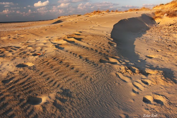 It was late in the day. The dunes and wildflowers already glowed orange. I found a pass between dunes as the sun set through the beachgrass and slept in the sand. I tried literally sleeping in the sand, which was a good insulator, but a cold wind blew over the beach and you can't really burrow into the sand.
 Dawn glowed orange over Zikhron Ya'aqov and Fureidis. It was light enough that I had no trouble seeing the sand dunes, soft and brown in the early morning. A few birds called, but otherwise the beach was peaceful and BAM.
What could possibly improve the morning more than random explosions to the northeast?
I walked in the other direction, back towards the stream, which rippled over the sand where it met the sea. Farther upstream, kingfishers staked out a shady pool. Even farther, egrets stalked the stream and ibises flapped around the fishponds. I walked around the dunes before heading out past the fishponds, long lens ready for birds. A family on bikes stopped by me. Actually, they stopped around me. I wasn't really surrounded but I couldn't see all of them at once.
"What kinds of birds are around here?"
 |
| (שלדג (יש אחד שם! עכשיו אף...לא, הינה הוא |
 |
| לבנית |
 |
| אנפה |
 |
| ועוד שאני לא יודע את שמם |
It was a long walk to the bus stop.
Friday, October 17, 2014
Around the Kinneret (also, secrets of not staying dry in a thunderstorm)
 |
| Egret across from the mountains and wadis of the northwestern shoreline of the Kinneret |
 |
| Marshes on the southeast shore |
 |
| Kinneret Trail between marshes and the Golan |
Evening drew in. I didn't know where to sleep. The beaches and marshes offered soft ground but the prospect of people. The steep, empty golden-brown hills of the Golan might have a tree where I could hang a hammock. Following instinct, I kept walking. By bad luck, I walked into a beach town as east-moving clouds glowed in the sunset, couldn't estimate its size, and headed for the hills. Much of the Golan is also firing zones. Every few minutes as the dusk advanced I stopped to check my map.
I lay down in an unused trail midway uphill but far above the wadi between the slopes above 'Ein Gev on the eastern coast. The dusk clouds moved further across the Kinneret, hiding and revealing the moon. Thunder crackled, then the rain came. I curled up in my sleeping bag, lined and waterproof in the hot night. Lightning flashed through the fabric and rain splattered over it.
Believe it or not, this is not my secret design for a rainproof shelter, and at this point, or at least after the second or third time that a storm came through that night, a rational being might have realized that a) this was not a comfortable way to spend the night, b) there was a highway and bus stop 200 m down the hill, and c) staying outside in a thunderstorm is foolish and risky. In my defense, a) I didn't care and the sleeping bag was waterproof anyway, b) ditto, and c) I was in the safest possible place to be outdoors in a thunderstorm, midway uphill, below the lightning and above the flood.
 |
| Sunrise clouds over the lake |
Due to my immense caution and foresight, I stayed fairly dry, or at least got dry by dawn. North of 'Ein Gev the beaches are open and the lakeshore is lined with smooth dark basalt rocks. Kingfishers and egrets flapped about as the sun began to shine above the wide, empty lake.
 |
| Looking down a wadi at the Kinneret |
 |
| Date palm in the evening near Capernaum |
Tuesday, September 23, 2014
Safed to Tiberias
 |
| Nahal Akbara and the cliffs above |
In the wadi, cattle grazed and birds chirped. The noon sky was perfectly clear, and everywhere was painfully bright. Gazelles ran (away) on the wooded cliffs. The small channel on the valley floor flowed gently with what might not have been sewage.
 |
| End-of-summer wildflowers at the edge of town, overlooking the wadi |
 |
| the Akbara mosque |
I turned right and followed the trail over the hill. The area was familiar from a sea-to-sea walk - ים לים - almost exactly two years ago. But I couldn't figure out how to cross the highway. The blazes, no help, pointed to a large hole. I looked for a sign or traffic light, then tried following the trail, which (you'd think I'd remember) followed the hole under the highway, climbed some steps, burrowed through a pipe, and followed a concrete path down to Nahal 'Amud, which really couldn't have been so muddy last time (or could it?). I recommend crossing that stream to anyone who likes Russian roulette. It works on the same principle, but messier and (so far as I know) nonviolently ; sometimes the water cools your feet, sometimes the mud sucks them in, not eternally (while all information is as correct as possible we cannot guarantee accuracy, follow my advice at your peril, etc...) but unpleasantly.
 |
| Stars above Mt. Arbel |
In the morning, or close enough anyhow, I continued up the road towards Arbel. Flocks of egrets flew through the valley, first silhouettes above, then, as I climbed, white figures below. The trail ascended steeper and steeper up the brown rock until it really was mountain climbing, over metal handbars sunk into the rock red and pink now from the sunrise. The summit was bare and flat, covered in dry grass. A falcon flew in from the east.
Tuesday, September 9, 2014
Foxes
 |
| A fox scratching itself in a valley below Mt. Tabor, about half an hour after sunrise |
 |
| Fox crossing the trail |
More foxes seemed likely. I waited at the crossroads. As long as I stayed fairly still they ignored me, crossing the path, scratching in the sunlight, walking lightly and quickly. One or two actually walked straight at me, head low, staring, close enough that it was easy to see the texture of their gray and brown fur, close enough that it was easy to see
 |
| Fox staring at me. Read what you like into its expression. |
 |
| Fox scratching by the side of a dirt road |
Sunday, August 24, 2014
Haifa to Daliyat el-Carmel
 |
| Dried resin on burned pine |
That should be Nahal Kelah, where I wanted to take a left and go up. There should be a trail up there. Maybe to the right of the riverbed. I tried it but found that it was impenetrable with no blazes. I checked my map again. Maybe to the left. Same thing. Checked the map again. I considered going straight up the riverbed, but it was impenetrable with no blazes. I turned right, frustrated - if I didn't find Nahal Kelah I would end up hiking the ancient paths to suburbia. After half a kilometer or so there was a perfectly well-marked trail - Nahal Kelah - heading the right way.
 |
| Hawk perched above Nahal Kelah |
I turned right at a bridge. More precisely, I stopped where a bridge blocked the riverbed, climbed up the canyon, and reached a red-blazed trail winding round the cliff. Things scrambled down the scrubby rocks. Furry things. A rock hyrax froze a few feet below the trail. It stared up at me. I stared down at it. I changed lenses very slowly. The hyrax saw no need to get out a camera of its own and stayed frozen. Another hyrax perched above the trail and stared down at me. I stared up at it...
 |
| The rock hyrax below the trail |
I crossed a road, took the trail towards Makhtzevot Qedumim (an ancient quarry, thus the name), taking a shortcut towards a parking area and a memorial to fire victims. A few years ago a fire destroyed much of the Carmel; blackened branches and recovering scrub cover most of the area from the memorial to Daliyat el-Carmel.
 |
| Burned stump on the open mountain |
White dust, bright and deep, covered the path up the open mountain. The view was clear to the Mediterranean, but by the end of the trail I was almost too tired to care. Trees reappeared, and the blue path ended at a confusing intersection. The left path became a dirt road leading through orchards and empty new neighborhoods to Daliyat el-Carmel. Actually, to just south of Daliyat el-Carmel. Following the sun doesn't work very well at high noon. The trail system was complex enough that I was lucky to get there at all.
Tuesday, August 19, 2014
Intro and Nahal Nesher
 |
| View to the east on the Nahal Nesher loop, about 3/4 of the way through |
The Nahal Nesher loop starts just below the University buildings on the Isfiya road. The right fork of a paved road leads to a gravel path leads to a windswept pine on an east-facing cliff. I knew this because I'd watched the sunrise there the day before. At home I set an alarm, woke up at dawn, and walked up the humid hill towards the windswept pine. On my way in I passed a small group camping illegally and sleeping peacefully. At the pine, I watched the sky and waited. I found a place just above the oak forest to set up a tripod. The sun rose after a quick small brightening in the clouds, already more white than yellow or red. Within a minute or two warm light shone on the pine needles and rocks. I found the trail entrance further on the paved road, just below a picnic area. A large trilingual sign told me that at least one person in my group had better have a 1:50,000 trail map. Oops. The blue-blazed trail headed more-or-less-
gently downhill, with a few left turns and pine branches scattered on the rock path, through what could be described as open forest, but only on average. Mostly either scrubland or claustrophobic. After maybe a kilometer (though I have no real idea) the forest cleared and I found myself walking on the edge of a cliff.
Not a particularly scary cliff, though. If I fell off, I would land on some very unfriendly bushes and rocks, but they were only about five feet down. Sunburn was a bigger risk. It was a very open cliff, though, and I had a wonderful view of the region's numerous and large skyscrapers. And construction sites. But once you're a thousand or so feet above them they look...OK. They'll never look charming. They look marginally less blightlike. There was also a view of the countryside and, to the east, a gorge between mountain ridges, hundreds of feet deep with hazy limestone shelves. It might have been carved two million years ago by a river, two thousand years ago by local stone cutters, or twenty years ago by ditto.
The path tended roughly west across the cliff, keeping level but curving among the hills for a kilometer or two. The view was hazy but on the rocks next to me the light never paled. Finally the trail abruptly turned left and curved up almost vertically through tall shady pines and gnarled katlav trees, red-barked and peeling. After a few hundred scrambling meters I climbed back up to the windswept pine. I had never seen it in full daylight and barely recognized it.
Subscribe to:
Posts (Atom)